Tomlinson Aviation, Inc
  • Home
  • About Us
  • What We Do
  • Flight Training
  • Tours
  • More services
    • LIDAR
    • Controlled Burning
    • Helicopter Transport
    • Aerial Application
    • Sales and Service
  • Contact Us
  • More
    • Home
    • About Us
    • What We Do
    • Flight Training
    • Tours
    • More services
      • LIDAR
      • Controlled Burning
      • Helicopter Transport
      • Aerial Application
      • Sales and Service
    • Contact Us
Tomlinson Aviation, Inc
  • Home
  • About Us
  • What We Do
  • Flight Training
  • Tours
  • More services
    • LIDAR
    • Controlled Burning
    • Helicopter Transport
    • Aerial Application
    • Sales and Service
  • Contact Us

LIDAR INSPECTION SERVICE

Welcome to the future!

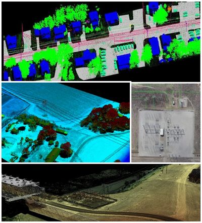
Power line patrol is becoming increasingly dependent on LiDAR imagery taken from helicopters and drones. Their excellent visibility and the ability to fly low and slow, or hover and land makes both platforms the most effective aerial patrol aircraft. 

What is LIDAR?

LIDAR uses ultraviolet, visible, or near infrared light to image objects. It can target a wide range of materials, including non-metallic objects, rocks, rain, chemical compounds, aerosols, clouds and even single molecules. A narrow laser beam can map physical features and the returned beam is translated into a 3D image with very high resolution.


Tomlinson Aviation services include aerial patrol inspection services, collection of aerial LIDAR and imagery (infrared & Corona technology) data ideally suited for various analysis and mapping. Primarily, the LIDAR data will be processed to generate clearance distance polygons for vegetation management, the color imagery (still & video) can be used for orthophoto creation, transmission structure photos, and visual inspection of the ROW. 


Infrared (IR) imagery can be used for dead tree identification, while the corona data can be used to detect and pinpoint flash-arc corona and arcing partial discharge locations on electric facilities (e.g. transmission & distribution lines, substations).


What industries utilize LIDAR?

The possibilities are almost endless in which LIDAR can be highly beneficial. The most common industries that are taking advantage of our LIDAR inspections include: agriculture, transportation, power distribution, and infrastructure. Give us a call to find out how we can make your company more successful. 


EQUIPMENT SPECIFICATIONS

  • 15 mm (0.59 inch) survey-grade accuracy with 10 mm (0.39 inch) precision
  • Scan speed up to 200 scans / second
  • Measurement rate up to 750,000 meas./sec
  • Operating flight altitude up to 1,740 ft
  • Field of view up to 330° for practically unrestricted data acquisition
  • Regular point pattern, perfectly parallel scan lines
  • Cutting edge RIEGL technology, which we chose over others because it provides:
        - echo signal digitization
        - online waveform processing
        - multiple-time-around processing
  • Multiple target capability - practically unlimited number of targets echoes
  • Compact (227x180x125 mm), lightweight (8.2 lbs), and rugged
  • Easily mountable to manned helicopters (RIEGL VP-1 Helipod)
  • Mechanical and electrical interface for IMU mounting
  • Electrical interfaces for GPS data string and Sync Pulse (1PPS)
  • Scan data storage on internal 240 GByte SSD Memory


The VUX-1LR Long Range is a very lightweight, compact and rugged laser scanner that has a proven history in the industry for superior accuracy & performance with highly repeatable and predictable results.


  • High resolution with a pixel count of 14204 x 10652
  • 3.76µm pixel size
  • 83dB Dynamic range (the luminance range of a scene being photographed. The better the dynamic range of the camera, the more an exposure can be pushed without significantly      increasing noise).
  • Backside-illumination technology (helps to get quality imagery in low light conditions)
  • 2 fps fast capture rate (aircraft speed has little to no effect on imagery (no motion blur) 
  • USB-C and 10G ethernet for versatility of connectivity
  • Camera supports super-fast storage capabilities with full control over a wireless link
  • Super-fast XQD storage card (XQD memory cards have speeds up to 440MB/s for data transfer and 400MB/s for data write). 


The PhaseOne 150mp camera enables increased productivity for a range of aerial image acquisition projects as it provides wider aerial coverage. Ultra-high resolution (14204 x 10652) and the backside-illuminated sensor enable perfect image quality, even in low light conditions resulting in more flying hours per day and more flight days per year.


Vegetation management applications include:


-Clearance distance measurements

-Vegetation prescriptions: (examples, can be easily modified or adjusted based on requirements)

  • Handcut chip
  • Light or heavy mowing
  • Bucket work
  • Tree removal maintained or unmaintained
  • Mechanical or manual side trim routine maintenance
  • Mechanical or manual side trim reclaim work

-Ground to conductor clearances

-Hazard or dead tree detection

-Tree inventory

-Change detection to support growth modeling

-Identification of vines

-Fast growing species identification

-Palm tree identification

-Category II tree and Category III tree identification

-Visualize encroachments within corridors (buildings, equipment, other dangers, for example 3rd party construction activities)

-Creation of 3D data, e.g. Digital Elevation Model, cross-sections, profiles

-Access road mapping

-Asset management

-Engineering modeling; new design, construction, as-built and/or re-conductoring

-PLS-CADD modeling supporting methods 1 through 4


LIDAR IN ACTION

Identify Category II Trees

Identify Category III Trees

Identify Category III Trees

Trees that are inside the ROW that have a fall-in potential can be identified. The LiDAR data can be analyzed to determine the location of potential Category II trees by comparing tree stem point features with the ROW boundaries. Once the candidates are located, LiDAR data will be reviewed to verify whether or not the tree stem is within the ROW. A point file can be created with Category II tree locations and delivered in Esri shapefile format.

Identify Category III Trees

Identify Category III Trees

Identify Category III Trees

Analysis of the LiDAR can be performed to determine the “fall in” vegetation outside of the ROW. For example, a danger tree area might be consider a tree that is 15’ outside of the ROW for 230 kV line. Any such tree inside the area that could fall at a point directly under the outside conductor could be targeted for removal. Category III trees deliverable can be Esri shapefile format.

Orthophoto imagery

Identify Category III Trees

Using aerial imagery data, create color orthorectified imagery at a ground sample distance of less than 6-inches. Orthophotos will cover the entire width of the ROW. Can be used to find dead trees and various ROW encroachments. Infrared imagery is another excellent tool for dying or dead vegetation identification. A file can be created with dead tree locations and delivered in Esri shapefile format.

Corona detection

Corona discharge is a luminous partial discharge from conductors and insulators due to ionization of the air, where the electrical field exceeds a critical value. By deploying a corona camera we can detect and pinpoint flash-arc corona and arcing partial discharge locations on electric facilities. An image tagged with geolocation can be delivered.

Field Access Data

Field Access Data

In order to aid in the evaluation of vehicle access to various areas of the transmission line ROW, field access data layers can be created. These data will be developed from the LiDAR data set as well as other existing data sources. Esri geodatabase is the delivery format.

The Field Access Data shall include roads --- including areas of significant rutting, fences, gates, hydrology features, contours, buildings, rail roads

LIDAR IMAGERY

CONTACT US FOR YOUR LIDAR NEEDS

Send us a message!

This site is protected by reCAPTCHA and the Google Privacy Policy and Terms of Service apply.

Tomlinson Aviation, Inc

joe@tomlinsonaviation.com (386) 676-0312

Copyright © 2025 Tomlinson Aviation, Inc - All Rights Reserved.

Powered by